


In brief: A robust front will bring much drier air into the Houston region today, and a couple of chilly nights in the upper 40s. After that Houston will likely experience warmer weather for the rest of March: think 80s with some humidity rather than the 70s we’ve had for much of the month. Summer is not here, but it is on the horizon.
Wednesday
Temperatures across much of the metro area this morning are in the range of 65 to 70 degrees, which is rather warm for mid-March. It’s also fairly sticky outside. However, this will end later this morning, as a fairly strong front moves into the area. We’ll feel this both in the form of northwesterly winds, gusting up to 20 or 25 mph, as well as much drier air. As skies clear out later today, with the drier air, expect high temperatures in the vicinity of 80 degrees.

Unfortunately for rodeo-goers, those winds will not let up much this evening. In fact, they should peak during the overnight hours, perhaps gusting up to about 30 mph. So be prepared for that. Temperatures after the show will be in the 60s, before lows tonight ultimately drop into the mid- to upper 40s for much of the metro area away from the coast.
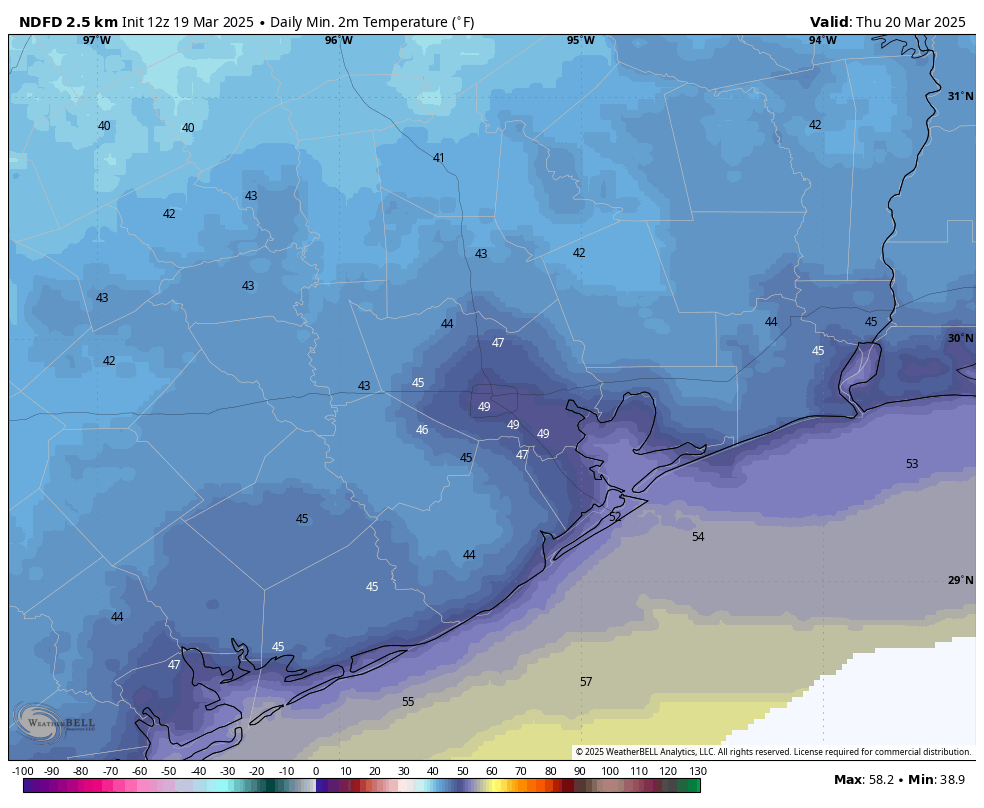
Thursday
This will be a sunny and pleasant day, with low humidity and highs of around 70 degrees. During the morning hours, at least, we should still see some modestly gusty winds. However by the afternoon these winds will likely slacken. Thursday night will be chilly again, with much of the region likely dropping into the upper 40s. Will this be the last time that parts of the Houston region get into the 40s this season? I think that’s quite possible.
Friday
Expect a sunny, pleasant day with highs in the mid-70s. Winds will turn southerly, gusting at times up to 20 mph. Expect overnight lows to only reach about 60 degrees with the warmer, southerly flow.
Saturday
The first half of the weekend brings more sunshine, with highs around 80 degrees. Dewpoints should still be in the 50s, so it will not feel too humid outside. Yet. Lows on Saturday night only drop into the mid-60s.
Sunday, Monday, and next week
With a more humid flow, expect temperatures to reach into the lower- to mid-80s on Sunday with likely increasing cloudiness. The question then is to what extent a slug of drier air will slide down from the northeast into the region. This is known as a “backdoor” front because instead of blowing down from the northwest, it edges in from the northeast. It’s likely that this system will generate a decent chance of rain, perhaps on the order of 50 percent during the period of Sunday afternoon through Monday morning. Accumulations don’t look that high, probably on the order of tenths of an inch.
Temperatures on Monday and Tuesday will depend on the extent to which the backdoor opens, and the amount of cooler and drier air that moves in. Perhaps we’ll have a couple of days in the 70s, with lows in the upper 50s. Maybe it will be a tad warmer. Most of the rest of next week should see highs in the 80s, however, with a decent amount of humidity. So it goes in Houston as we get nearer the end of March: fewer fronts and more humidity.


